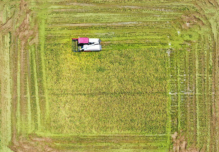
A BDS-powered harvester is in operation on a field in a village in Nanchang, Jiangxi Province, on 20 July 2022
Large maize harvesters with autopilot system are significantly enhancing the productivity of local farmers in Botou, north China's Hebei Province, who are excited about the fact that the cutting-edge technologies are freeing up their hands. According to Li Tielian, an official from the city's Bureau of Agriculture and Rural Affairs, there are more than 200 smart farming machines in the city, including drones, sprayers, seeding machines, tractors and harvesters, all of which are supported by the BeiDou Navigation Satellite System (BDS).
To effectively monitor autonomous harvesters at work, farmers just define the routes and settings using the BeiDou positioning service and 5G technology. It is anticipated that autonomous harvesting would boost output and decrease grain losses.
On 31 July 2020, China launched its independently built and run BDS, which has since been adopted by a number of different industries. The combined use of BeiDou intelligent monitoring terminals and assisted driving systems will be encouraged, according to this year's No.1 Central Document, an official document on agriculture released in February. In recent years, BDS has been used to improve farming efficiency at various stages of agricultural production, including ploughing, planting and harvesting.
Hi-tech farming
Heilongjiang Province in northeast China is the country's primary producer of grain. According to Han Zhimin, director of a crop planting cooperative in Yilan County of the province, BDS-related agricultural technologies are playing an increasingly important role in improving farming efficiency. Last year, more than 8,000 mu (533 hectares) of soybeans were planted by Han's cooperative. BDS was widely used in land management, and the output hit a record of 265 kg per mu (0.067 hectares).
Grain harvest can be affected by plant diseases, pests, crop lodging, etc. Qu Hui, head of the science and technology division of Beidahuang Group of Heilongjiang Province, demonstrated the "one-key field inspection" on a control platform on a farm of the group. A drone flew to the pre-set plot with a click of the mouse to gather data, which was then displayed in real time on the big screen. In addition, several autonomous windrowers outfitted with 5G and BDS are used in a rice field owned by the group during the harvest time, enhancing harvesting accuracy and drastically lowering crop losses.
The conventional agricultural landscape has undergone a change thanks to intelligent agricultural gear, and this is something that many manufacturers of agricultural machinery are undertaking. In recent years, World Agriculture Machinery Co., based in Zhenjiang of Jiangsu Province, has seen a surge in sales of its BDS-propelled rice transplanters. The company has got orders for almost 200 such transplanters and 25,000 units of different agricultural gears this year.
According to a report by China Central Television, by 2022, China's smart agricultural machines with BeiDou positioning systems had surpassed 900,000 units, improving working efficiency by more than 20 percent.
BDS can also be used in other industries. According to the white paper titled China's BeiDou Navigation Satellite System in the New Era published by the Information Office of the State Council in November 2022, BDS has embarked on the fast track of large-scale application, and by 2021, the overall output value of the satellite navigation and positioning services industry has reached about 470 billion yuan ($69.24 billion).
The report suggested that a number of services, including global positioning, navigation, search and rescue may be offered via BDS. It is the first satellite navigation system in the world to offer a service for international short message communications.
Yang Changfeng, chief designer of BDS and an academician of the Chinese Academy of Engineering, predicted that the BDS applications would reach the scale of 1 trillion yuan ($144.8 billion) by 2025 with an average annual growth rate of 20 percent. This is because BDS is constantly enhancing and improving its capabilities.

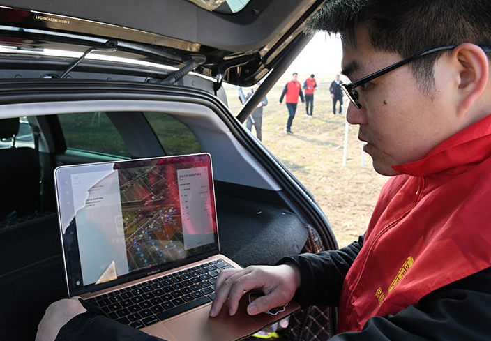
An agricultural technician downloads and analyses data collected by a drone with BDS on a farm in Laixi, Shandong Province, on 28 February
Cooperation on a global scale
BDS is welcoming all nations to participate in the development and application of the system. Statistics show that BDS is used in more than half of the nations and regions in the world, and it is promoting regional development.
BDS and related products are being deployed in a growing number of African countries as China's first space infrastructure is delivering public services globally.
The city of Xai-Xai in Mozambique's Gaza Province is home to the largest rice-growing project in Africa, covering 20,000 hectares. For local farmers, cultivating and harvesting such a vast area of rice fields is a challenging task.
The BDS-based agricultural advancements have relieved farmers of some of their burdens. To operate the drone, one just needs to launch the appropriate app on the cellphone. BeiDou's positioning data allows the drone to spray pesticides along a predetermined route. In comparison to 3 to 4 mu (0.2-0.27 hectares) when done by hand, the drones can spray pesticides over 100 mu (6.7 hectares) every hour.
The Sino-Arab BeiDou/GNSS Centre, located in Tunis, capital of Tunisia, is the first Chinese BeiDou centre abroad. The centre can provide satellite navigation training, testing and evaluation, and technical research for African and Arabian countries.
China aims to develop a comprehensive nationwide positioning, navigation and timing (PNT) service system based on BDS that is ubiquitous, more integrated and intelligent by 2035 to provide essential support for the development of intelligent and autonomous systems. According to the white paper, BDS will be able to better serve users around the world by providing a highly reliable PNT service.
(Original Title: Smart Agriculture)
Category
Smart Agriculture: Navigation Technology Contributes to the Modernisation of Agriculture
Contributor
Smart Agriculture: Navigation Technology Contributes to the Modernisation of Agriculture
Country
Technical Solution

